ChinaDrone.Request a quote ↗
COMPONENT

ZHZS-4GBK

By Shenzhen Zhonghang Zhisheng Communication Technology Co., Ltd. ↗

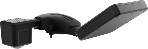
ZHZS-4GBK is a 4G wireless emergency deployment PTZ camera for emergency command and public-service applications.

Request a quote ↗

Product overview

The ZHZS-4GBK from Shenzhen Zhonghang Zhisheng Communication Technology Co., Ltd. is a 4G wireless emergency deployment PTZ camera with a black metal body measuring 139 × 229 mm. Its stated application areas include emergency command, public security, investigation, traffic policing, firefighting, civil air defense, epidemic prevention, urban management, electric power, railways and road administration.

Tell us the specifications you need. We can discuss the exact model and configuration for your project.

SOURCE WITH CHINADRONE

Request a quote for ZHZS-4GBK

Send your application, destination country and expected quantity to the ChinaDrone team. We can discuss product selection, configuration and sourcing from China.

Submit your procurement requirements ↗

No account needed. A model number is optional. Your enquiry is handled by ChinaDrone.
KEEP EXPLORING

Similar products

Browse all products ↗
MF30-M4/M30 drone water-flow measurement payload
Cameras & sensors

MF30-M4/M30

By CZI

The CZI MF30-M4/M30 is a small-UAV radar payload for surface-water velocity and reference water-level measurement. Its two variants integrate with DJI MATRICE 4 or Matrice M30 series aircraft. Dedicated czi Pilot software supports controller-based measurement, automated routes, data export and river-discharge calculations.

Cameras & sensors

FS6B Airborne Full-Spectrum Hyperspectral Camera

By Caipu Keji (Zhejiang)

The Caipu Keji (Zhejiang) FS6B is an airborne hyperspectral camera system integrating VISNIR and SWIR imaging across 400-2500nm. Embedded acquisition, processing and storage support spectral collection for soil, mineral, agricultural, forestry, ecological and military camouflage applications. Its configuration includes USB3.0 connectivity, application software and real-time observation through a ground station.