Product overview
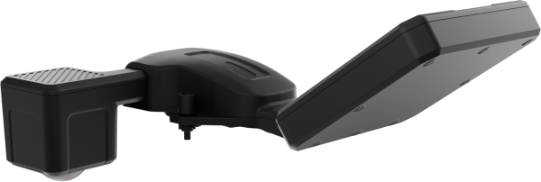
The CZI MF30-M4/M30 is a compact measurement payload for small UAVs, intended for flood response and routine water-management inspections. Its physical architecture combines a radar detector with a radar velocity meter, supporting surface-water velocity and reference water-level measurements. Aircraft integration is variant-specific: the 108g MF30-M4 fits DJI MATRICE 4 series aircraft, while the 250g MF30-M30 fits DJI Matrice M30 series aircraft. This is a UAV payload configuration, with dedicated measurement software, rather than a complete flight platform. A single operator can complete deployment in two minutes.
The accompanying czi Pilot software brings measurement, route planning, data processing, export and discharge calculation onto the aircraft remote controller. Manual flight supports individual measurement points, with velocity and water-level results stored as tables; automatic missions retain measurements along configured routes. River cross-sectional discharge calculation requires imported cross-section data alongside measured flow data, with adjustable formulas and parameters. The workflow also supports cloud synchronization and chart visualization. Selectable water-level datums, multiple discharge formulas, and bank and surface coefficient factors provide configuration options for hydrological calculations.
Specifications
| Specification | Value & conditions |
|---|---|
| Product | CZI MF30-M4/M30 UAV water-flow measurement payload |
| Product configuration and measurement functions | Payload for small UAVs, incorporating surface-water velocity measurement, reference water-level measurement and dedicated flow-measurement software |
| Applications | Rapid deployment for flood emergencies and routine water-management inspections |
| Deployment time | 2 minutesSingle-person deployment. |
| MF30-M4 weight | 108gMF30-M4 configuration. |
| MF30-M30 weight | 250gMF30-M30 configuration. |
| MF30-M4 aircraft integration | DJI MATRICE 4 series UAVsMF30-M4 configuration. |
| MF30-M30 aircraft integration | DJI Matrice M30 series UAVsMF30-M30 configuration. |
| Sensor architecture | Integrated radar detector and radar velocity meter |
| Live measurement display | Real-time water-flow data for the current measurement point displayed on the remote controller, with a high data refresh rate |
| Included software workflow | Czi Pilot dedicated measurement software supports real-time flow measurement, route planning, data processing and export, and discharge calculationUsing the UAV remote controller. |
| Manual measurement and storage | Measures water velocity at individual points and stores measured velocity and water-level data as tables on the remote controllerManual aircraft flight and single-point measurement. |
| Automatic measurement | Supports point-directed or route flight tasks, automatic mission execution and storage of flow measurements from every measurement point along the routeAfter creating or importing a route file and setting parameters. |
| Cross-sectional discharge calculation | Calculates river cross-sectional discharge using adjustable calculation formulas and parametersWith imported river cross-section data and measured flow data. |
| Cloud synchronization and visualization | Synchronizes flow-measurement data to a UAV platform in the cloud and presents data as visual charts |
| River discharge algorithm | Adaptive river-discharge algorithm jointly developed with universities |
| Water-level reference selection | Selectable water-level references, including the Pearl River and Wusong datums |
| Discharge formula selection | Multiple discharge formulas, including the area–velocity method, international method and Li Wen method |
| Coefficient calibration | Multiple calibration factors, including bank and surface coefficients |
Request a quote for MF30-M4/M30
Send your application, destination country and expected quantity to the ChinaDrone team. We can discuss product selection, configuration and sourcing from China.
Submit your procurement requirements ↗No account needed. A model number is optional. Your enquiry is handled by ChinaDrone.