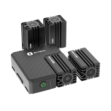
Product overview
Bytech Technology Co., Ltd.’s LG10 is a drone-mounted laser and lighting accessory for target guidance, projected warnings, reconnaissance and fill lighting. Its snap-on mount attaches directly to a gimbal lens so the equipment follows lens movement during operation. The 66mm × 60mm × 21mm host weighs 179g ±4% and combines ABS and aluminum alloy construction with passive cooling. Quick-release installation and hot-swappable lamp caps allow changes between the listed point, mapping, infrared fill-light and LED lighting functions. Adaptable lenses include the Zenmuse and Z series.
The LG10 uses an independent power supply with a 700mAh battery and specifies 50 minutes of endurance at standard brightness. Its 2000m irradiation distance applies to point light, while control distance follows the drone link. Operation uses the drone remote controller, with DJI Pilot control mode also identified. LD20 and LD25 communication modules connect third-party loads to the aircraft through a wireless link; both have E-Port interfaces and RGB indicators. The LG10 is payload equipment rather than a flight platform or airframe kit.
Specifications
| Specification | Value & conditions |
|---|---|
| Mapping warning height | 20–100 mWith the laser mapping module. |
| Product name | Laser guidance and mapping system |
| Model | LG10 |
| Dimensions | 66mm × 60mm × 21mm |
| Weight | 179g ±4% |
| Rated power | 10W |
| Rated voltage | 5V |
| Current | 2A |
| Power supply | Independent power supply |
| Control distance | Consistent with drone link |
| Control method | Drone remote control |
| Ingress protection | IP55 |
| Irradiation distance | 2000mPoint light. |
| Laser and lighting modules | 520nm point; 520nm mapping; 850nm fill light; LED lighting |
| Endurance | 50 minutesStandard brightness. |
| Battery capacity | 700mAh |
| Lamp-cap hot replacement | Supported |
| Cooling | Passive |
| Materials | ABS and aluminum alloy |
| Installation | Quick-release |
| Adaptable lenses | Zenmuse series, Z series, etc. |
| Operating temperature | -25°C to 55°C |
| Storage temperature | −30°C to 60°C |
| Control-module model | LD20LD20 control module. |
| Control-module dimensions | 51mm × 26mm × 24mmLD20 control module. |
| Control-module weight | 14gLD20 control module. |
| Interface and outputs | E-Port; outputs: 24V, 5VLD20 control module. |
| Status indicator | RGBLD20 control module. |
| Control-module model | LD25LD25 control module. |
| Control-module dimensions and weight | 50.5mm × 24.5mm × 37.6mm; 15.5gLD25 control module. |
| Interface and status indicator | E-Port; RGB status indicatorLD25 control module. |
Request a quote for LG10
Send your application, destination country and expected quantity to the ChinaDrone team. We can discuss product selection, configuration and sourcing from China.
Submit your procurement requirements ↗No account needed. A model number is optional. Your enquiry is handled by ChinaDrone.