Product overview
The YAHREE Q353 combines three sensing modules in a drone gimbal pod: a visible-light camera, a thermal imager and a laser rangefinder. This configuration supports observation, target identification, tracking and positioning, with coordinate calculation for the target at the center of the screen. Visible imaging provides 1920 × 1080 resolution, while the thermal channel pairs a 1280 × 1024 sensor with a 55 mm lens. Laser ranging extends from 15 m to 3000 m.
For payload integration, the Q353 weighs 1883 ± 10 g and offers speed and angle control through S.BUS, TTL UART, TCP or UDP. Its gimbal control envelope is 360° × N in yaw, −120° to 30° in pitch and ±40° in roll. Video output is 1920 × 1080 at 30 fps, with MP4 video and JPEG photo storage. Target handling includes a 3-second reacquisition function. The product configuration is an integrated camera payload for a drone.
Specifications
| Specification | Value & conditions |
|---|---|
| Product configuration | AI three-sensor gimbal camera integrating visible-light imaging, thermal imaging and laser rangefinding. |
| Specified construction material | Aircraft-grade aluminum. |
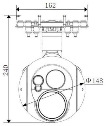
| Dimensions | 156×5 (L) × 148 (W) × 240 (H) mm. |
| Weight | 1883 ± 10 g. |
| Gimbal control angle range |
|
| Control modes | Speed control; angle control. |
| Control signals | S.BUS, TTL UART, TCP, UDP. |
| Visible-light resolution | 1920 × 1080. |
| Video output | 1920 × 1080 @ 30 fps. |
| Thermal imaging focal length | 55 mm. |
| Thermal imaging resolution | 1280 × 1024. |
| Laser ranging limits | 15 m to 3000 m. |
| Video storage format | MP4. |
| Photo storage format | JPEG. |
| Target functions | Target search, identification, tracking and positioning, with a 3-second target reacquisition function. |
| Target coordinate calculation | Supports calculation of target longitude and latitude.For the target at the center of the screen. |