ChinaDroneRequest a quote →

MoneyPro RTK GNSS Antenna MT-304

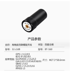
The MoneyPro RTK GNSS Antenna MT-304 is a compact positioning antenna for high-precision GNSS applications. Supporting GPS, BDS, GLONASS and GALILEO, it combines high gain and sensitivity with interference resistance for surveying, mapping, construction layout, precision agriculture and moving-carrier positioning.

MoneyProDrone GPS

Get a free quote

Product overview

The MT-304 supports key bands of GPS, BDS, GLONASS and GALILEO for professional positioning work. Its miniaturized design combines high gain and high sensitivity with anti-interference capability and low phase center variation. Resistance to water, dust and extreme temperatures supports operation in demanding environments, while compatibility with various RTK receivers allows its use in high-precision GNSS positioning systems.

Applications include land surveying, precision mapping, construction layout and precision agriculture. The antenna also works with a wide range of satellite navigation receivers to support positioning and speed measurement for moving carriers in high-dynamic environments. Its broader uses include navigation scheduling, tracking and monitoring, and measurement and control.
Flight control & navigation

Specifications

MoneyPro RTK GNSS Antenna MT-304 specifications
SpecificationValue & conditions
Product typeMoneyPro MT-304 RTK GNSS positioning antenna for high-precision GNSS applications
Satellite system supportSupports key bands of GPS, BDS, GLONASS and GALILEO
Design characteristicsMiniaturized design with high gain, high sensitivity and strong reliability
Interference resistance and phase centerAnti-interference capability and low phase center variation
Environmental resistanceResistance to water, dust and extreme temperatures
Receiver compatibilityIntegrates with various RTK receivers
Moving-carrier functionsSupports positioning and speed measurement requirements of moving carriersHigh-dynamic environments.
Precision positioning applicationsLand surveying, precision mapping, construction layout and precision agriculture
Additional applicationsNavigation scheduling, tracking and monitoring, and measurement and control

Related guides