Product overview
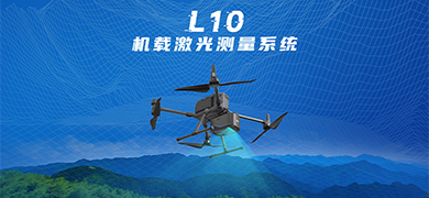
The L10 is an airborne laser measurement system for capturing high-accuracy point clouds and imagery. It attaches to DJI M350-series drones through the DJI SKYPORT interface as a plug-and-play unit, and the DJI M300 and M350 are the recommended carrier aircraft. One drone remote controller operates both the aircraft and the scanner, and a physical button starts data capture with one press. The unit measures 220 x 120 x 150 mm, weighs 1.55 kg and has 1 TB of onboard storage. It draws a typical 40 W, is rated IP64 and works from -20 °C to +55 °C. Typical uses include topographic mapping, highway survey and design, power-corridor inspection, forestry surveys, emergency disaster assessment and mine surveying.
The scanner uses a single-line, eye-safe Class 1 laser with an 80° field of view and up to eight returns. Maximum range is 900 m on targets with at least 60% reflectivity at a 100 kHz pulse rate, and this figure may vary in other operating environments. The laser has three pulse-rate settings: 100 kHz, 300 kHz and 550 kHz. Because total laser power is fixed, a higher pulse rate lowers the maximum supported flight height. The limits are 150 m at 550 kHz, 250 m at 300 kHz and 350 m at 100 kHz. These values were measured at Hi-Target's test site on targets with more than 15% reflectivity and may differ elsewhere.
The 18 mm full-frame camera is built into the same unit as the laser and cannot be removed or replaced with another camera. For point clouds alone, flying at or below 300 m meets 1:500 density and accuracy requirements. When imagery is also needed, the 18 mm camera should be flown at 230 m or lower. The system is rated for 1:1000 orthophoto work without image control points. For 1:500 work, surveyed control points are recommended, and orthophoto deviation is typically within 1 to 3 pixels. Because camera distortion changes with temperature, humidity and atmospheric clarity, the camera should be recalibrated for each project or flight. On a DJI aircraft with new batteries, safe flight time can exceed 30 minutes. This figure comes from Hi-Target test-site measurements and may vary in other operating environments.
Specifications
| Specification | Value & conditions |
|---|---|
| Host platform interface | Fits DJI M350-series drones via the DJI SKYPORT interface, plug-and-play |
| System accuracy | 5 cm @ 300 mAt 300 m |
| Dimensions | 220 x 120 x 150 mm |
| Main unit weight | 1.55 kg |
| Data storage capacity | 1T |
| Data copy speed | 160M/s |
| Typical power | 40 W |
| Operating temperature | -20 °C to +55 °C |
| Ingress protection | IP64 |
| Maximum operating efficiency on M350 | 3.0 km² per flight at 300 m; 1.0 km² per flight at 120 mMounted on DJI M350; 300 m flight height for 3.0 km², 120 m flight height for 1.0 km² |
| Laser safety class | Class 1 (eye-safe) |
| Laser wavelength | 1535 nm |
| Maximum range | 900 mTarget reflectivity ρ = 60% |
| Ranging accuracy / repeatability | 15 mm / 5 mmAt 150 m |
| Maximum pulse rate | 550 kHz |
| Maximum scan line speed | 260 lines/s |
| Laser field of view | 80° |
| Returns | 8 returns |
| Laser beam divergence | 0.55 mrad |
| Angular resolution | 0.001° |
| GNSS support | GPS L1/L2/L5; GLONASS L1/L2; BeiDou B1/B2/B3; Galileo E1/E5a/E5b |
| Inertial data update rate | 500 Hz |
| Post-processed attitude accuracy | Roll/pitch 0.006°; heading 0.019°Post-processed |
| Post-processed position accuracy | Horizontal 0.01 m; vertical 0.02 mPost-processed |
| Camera image resolution | Full-frame, 45 megapixelsIntegrated camera |
| Camera focal length | 18 mmIntegrated camera |
| Camera sensor size | 36 x 24 mm (8192 x 5468 px)Integrated camera |
| Camera pixel size | 4.4 μmIntegrated camera |
| Camera field of view | 90.0° x 67.4°Integrated camera |
| Minimum photo interval | 1 sIntegrated camera |
Request a quote for Hi-Target L10
Send your application, destination country and expected quantity to the ChinaDrone team. We can discuss product selection, configuration and sourcing from China.
Submit your procurement requirements ↗No account needed. A model number is optional. Your enquiry is handled by ChinaDrone.