ChinaDroneRequest a quote →
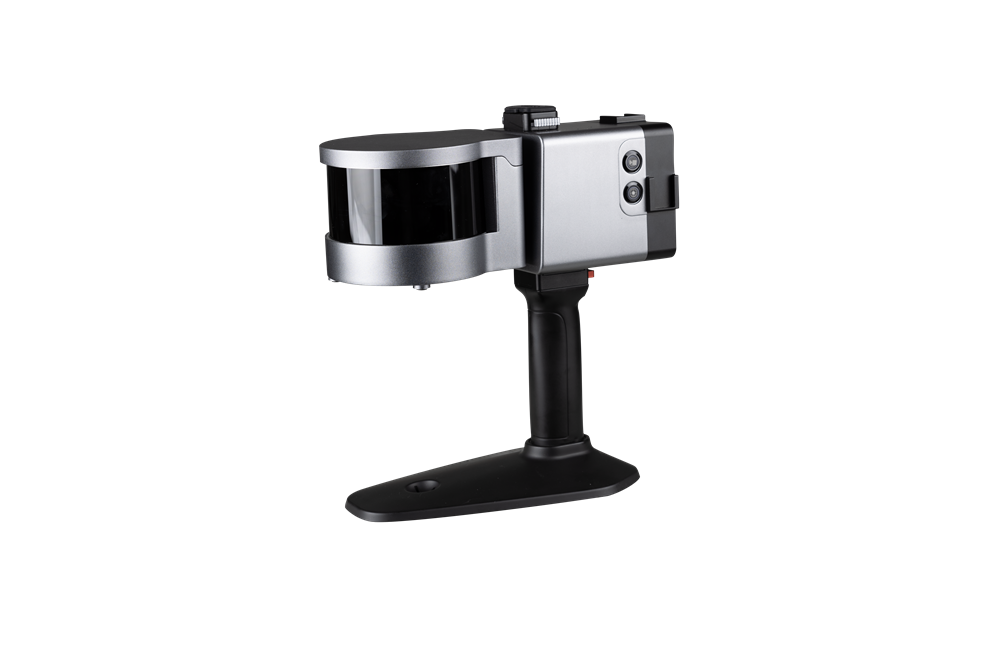
LS300 handheld three-dimensional laser scanner with silver housing and a black handleLS300 handheld three-dimensional laser scanner with silver housing and a black handle

Sinan Daohang LS300

The discontinued Sinan Daohang LS300 is a lightweight three-dimensional laser scanner using SLAM for real-time positioning and mapping without GNSS. It supports indoor and outdoor surveys in handheld, backpack, vehicle-mounted and UAV kit operating modes, with a rotating laser sensor, true-color point clouds and point-cloud processing software.

Sinan DaohangPayloads & thermal cameras
Applications
Smart cities, underground infrastructure digitization, agriculture, forestry, geology, surveying and mapping

Get a free quote

Product overview

The discontinued Sinan Daohang LS300 three-dimensional laser scanner combines a lightweight design with SLAM for real-time positioning and mapping. It performs self-positioning and incremental positioning without relying on GNSS, supporting three-dimensional surveys in unknown indoor and outdoor environments. Synchronous acquisition collects data while the operator walks. Its rotating laser sensor has a working distance of 120m, large-scene scanning coverage up to 360° × 285°, and point accuracy that can reach 1.0cm. Applications include smart cities, underground infrastructure digitization, agriculture, forestry, geology, surveying and mapping.

The LS300 supports handheld, backpack, vehicle-mounted and UAV kit operating modes. Its HSL hybrid solution post-processes earlier data during scanning, while anchor-point computation supports scanning accuracy and stability. Entering absolute control-point coordinates enables overall dataset correction. A larger color screen, app-based real-time point-cloud preview and true-color point clouds provide ways to view survey data. Battery hot swapping and replacement are supported by a redundancy design for uninterrupted operation. Post-processing software offers multiple point-cloud import and export formats, one-click denoising, stitching and shadow rendering, plus compatibility with third-party post-processing software.
Cameras & sensors

Specifications

Sinan Daohang LS300 specifications
SpecificationValue & conditions
Product type and statusLS300 three-dimensional laser scanner; discontinued
Positioning and mapping technologySLAM (simultaneous localization and mapping) with real-time positioning and mapping
GNSS-independent positioningSelf-positioning and incremental positioning without reliance on GNSS
Mapping environmentsThree-dimensional mapping in unknown indoor and outdoor environmentsIndoor and outdoor environments
ConstructionLightweight design
Data collectionSynchronous data acquisition while walkingDuring walking surveys
Laser sensorRotating laser sensor probe
Working distance120m
Scanning coverageUp to 360° × 285°Large-scene scanning
Point accuracyCan reach 1.0cm
HSL processingHSL hybrid solution with post-processing of previously collected data during scanningDuring scanning
Anchor-point computationAnchor-point computation supports scanning accuracy and stability
Dataset correctionOverall dataset correction using absolute control-point coordinatesWith absolute control-point coordinates entered
DisplayUpgraded, larger color screen displaying more information
Point-cloud previewReal-time point-cloud preview with multiple browsing and interaction methodsUsing the app
Color point cloudsTrue-color point-cloud functionality
Battery handlingHot-swappable, replaceable batteries with an uninterrupted-operation redundancy designDuring battery replacement
Point-cloud file handlingPoint-cloud loading and export in multiple formatsUsing the data post-processing software
Processing functionsOne-click point-cloud denoising, point-cloud stitching and shadow renderingUsing the data post-processing software
Third-party processingData processing compatibility with third-party post-processing software
Survey operating modesHandheld, backpack, vehicle-mounted and UAV kit operating modesHandheld kit, backpack kit, vehicle mounting kit or UAV kit configuration
ApplicationsSmart cities, underground infrastructure digitization, agriculture, forestry, geology, surveying and mapping

Related guides