ChinaDroneRequest a quote →

MT-600

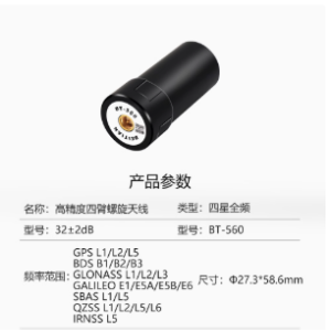
The Moneypro MT-600 is a compact, lightweight RTK GNSS antenna for professional precision positioning. Supporting GPS, BDS, Galileo and GLONASS with full-frequency coverage, it combines high gain and high sensitivity for applications including UAV surveying, handheld positioning terminals and small RTK measurement equipment.

MoneyProDrone flight controller

Get a free quote

Product overview

The Moneypro MT-600 is an RTK GNSS measurement antenna for precision positioning applications. It combines GPS, BDS, Galileo and GLONASS support with full-frequency coverage to provide signal reception for systems pursuing centimeter-level positioning. High gain and high sensitivity support its positioning role, while multi-system compatibility allows use with a variety of satellite navigation receivers. Its compact, lightweight design makes it suitable for portable equipment and integration into positioning systems.

Applications span UAV surveying and mapping, handheld positioning terminals and small RTK measurement equipment. The MT-600 also serves geodetic surveying, channel surveying, precision agriculture and marine surveying, bringing its multi-constellation reception capabilities to a broad range of professional measurement tasks. With portability and easy integration central to its design, the antenna accommodates applications that combine satellite navigation receivers with compact measurement equipment for accurate positioning in complex environments.
Flight control & navigation

Specifications

MT-600 specifications
SpecificationValue & conditions
Product typeMoneypro MT-600 RTK GNSS antenna
Supported satellite constellationsGPS, BDS, Galileo and GLONASS
Frequency coverageFull-frequency measurement antenna
Positioning roleSupports centimeter-level positioning
Physical designCompact, lightweight design for portability and integration
Antenna characteristicsHigh gain, high sensitivity, miniaturization, multi-system compatibility and high reliability
Receiver compatibilityCompatible with a variety of satellite navigation receivers
Positioning equipment applicationsUAV surveying and mapping, handheld positioning terminals and small RTK measurement equipment
Surveying and agricultural applicationsGeodetic surveying, channel surveying, precision agriculture and marine surveying

Related guides