Product overview
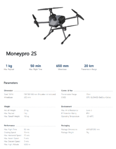
The China Moneypro 2S carries up to 1 kg and supports LiDAR, multispectral sensors and thermal cameras for precision agriculture, infrastructure inspection, mapping and surveillance. Agricultural uses include multispectral crop analysis and irrigation planning, while inspection applications cover power lines, wind turbines and bridges. Maximum flight time is 50 minutes, with a maximum horizontal speed of 20 m/s and ascent/descent speed of 5 m/s. Its encrypted, low-latency HD video transmission reaches 20 km, alongside a 20 km control range. RTK/PPK positioning supports GPS, GLONASS, BeiDou and Galileo, with optional centimeter-level RTK accuracy.
Built around a 650 mm wheelbase, the 2.1 kg aircraft folds to 510 × 510 × 400 mm and uses quick-release propellers for fast assembly. Maximum takeoff weight is 4.8 kg. Its IP54 protection provides dust and water resistance, while Level 6 wind resistance supports stability in 12 m/s winds. The operating temperature range is -20°C to 60°C. Automatic obstacle avoidance and return-to-home complement its flight capabilities. The supplied drone, battery and remote have a shipping weight of 7 kg, with package dimensions of 615 × 620 × 250 mm.