ChinaDroneRequest a quote →
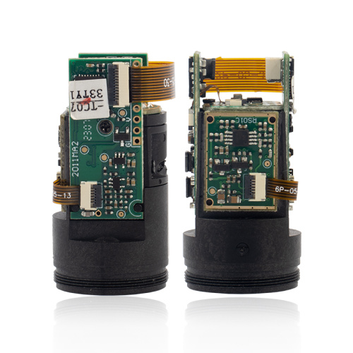
Meskernel TC22 cylindrical laser rangefinder module shown from two sidesMeskernel TC22 cylindrical laser rangefinder module shown from two sides

Meskernel TC22

The Meskernel TC22 is a compact cylindrical laser rangefinder module for drones, UAVs and other distance measurement systems. Measuring ⌀ 22*43mm and weighing 15 grams, it offers a range of 3 to 1000 meters, ±1 meter accuracy and USART/RS232/RS485 interfaces.

MeskernelPayloads & thermal cameras
Weight
15 grams
Size
⌀ 22*43 mm

Get a free quote

Product overview

The Meskernel TC22 is a Long Distance Series laser ranging module with a compact cylindrical body measuring ⌀ 22*43mm and weighing 15 grams. Designed for integration into drones and UAVs, it supports altitude measurement, obstacle detection and terrain mapping. Its 3 to 1000 meters measurement range and ±1 meter accuracy also serve industrial automation tasks, including manufacturing processes, quality control and material handling, as well as land surveying, construction planning, topographical mapping and robotic navigation.

The TC22 operates at 1-3 Hz and uses a 905 nm Class Ⅰ laser with power below 1 mW. Supporting interfaces are USART/RS232/RS485 for system integration. Its operating temperature range is 0~50℃, and its storage temperature range is -30~60℃. The module carries a three-year warranty, with OEM, ODM and OBM customization supported. For robotic systems, its distance measurement capabilities support navigation and obstacle avoidance.
Cameras & sensors

Specifications

Meskernel TC22 specifications
SpecificationValue & conditions
ProductMeskernel TC22 cylindrical laser rangefinder module
Product seriesLong Distance Series, Model TC22
Range3 to 1000 meters
Size⌀ 22*43mm
Weight15 grams
Accuracy±1 meter
Frequency1-3 Hz
Laser wavelength905 nm
Laser classClass Ⅰ
Laser powerLess than 1 mW
Operating temperature0~50℃
Storage temperature-30~60℃
Supporting interfacesUSART/RS232/RS485
Warranty period3 years
CustomizationOEM, ODM, OBM
Drone and UAV applicationsAltitude measurement, obstacle detection and terrain mapping
Industrial automation applicationsDistance measurement for manufacturing processes, quality control and material handling
Surveying and mapping applicationsLand surveying, construction planning and topographical mapping
Robotics applicationsNavigation, obstacle avoidance and distance measurement

Related guides