ChinaDroneRequest a quote →
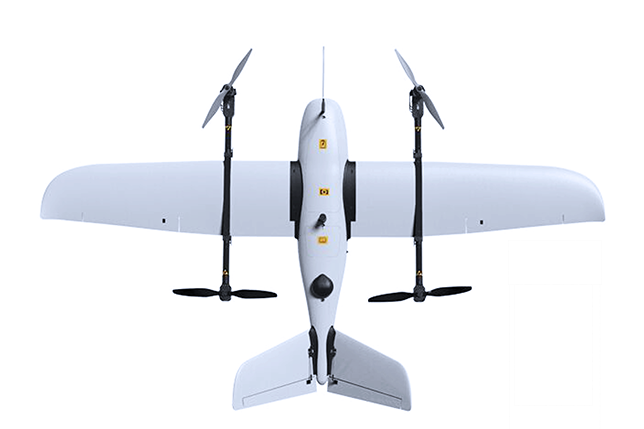
makeflyeasy Freeman 2100 VTOL fixed-wing UAV viewed from abovemakeflyeasy Freeman 2100 VTOL fixed-wing UAV viewed from above

Freeman 2100

The makeflyeasy Freeman 2100 is a tilting VTOL fixed-wing aerial survey UAV with a 2100mm wingspan. Built from EPO, ABS and carbon fiber, it features tool-less disassembly and a recommended 600g payload for mapping, surveying, planning, agricultural and environmental monitoring applications.

makeflyeasyAgricultural drone
Flight time
80 min
Wingspan
2100 mm

Get a free quote

Product overview

The makeflyeasy Freeman 2100 is a tilting vertical takeoff and landing fixed-wing aerial survey UAV developed from the Believer. Its EPO, ABS and carbon fiber construction has a 2100mm wingspan and a 1070mm fuselage. Tool-less disassembly supports handling and transport, with transport box dimensions of 1.1m×0.29m×0.43m. The load compartment measures 120*150*120mm, the recommended payload is 600g, and maximum take-off weight is 6.5kg.

For aerial survey operations, the Freeman 2100 combines VTOL take-off and landing with a recommended cruising speed of 65km/h (18m/s). Flight time is 80min, with a maximum range of 80km at a 600g load. Practical lift altitude is 4000m and wind resistance is Class 5. Applications span topographic mapping, land and engineering surveys, digital city work, planning and construction, landscape planning, precision agriculture, environmental protection monitoring and ecological monitoring.
AgricultureSurveying & inspection

Specifications

Freeman 2100 specifications
SpecificationValue & conditions
Product typeTilting vertical takeoff and landing fixed-wing aerial survey UAV, modified on the basis of the Believer
MaterialsEPO+ABS+Carbon Fiber
Wingspan2100mm
Fuselage1070mm
Disassembly methodTool-less disassembly
Load compartment size120*150*120mm
Transport box size1.1m×0.29m×0.43m
Maximum take-off weight6.5kg
Recommended payload600g
Take-off and landing modeVTOL
Practical lift altitude4000m
Recommended cruising speed65km/h (18m/s)
Wind resistanceClass 5
Flight time80min
Maximum range80km600g load.
ApplicationsTopographic mapping, land survey, engineering survey, digital city, planning and construction, landscape planning, precision agriculture, environmental protection monitoring and ecological monitoring