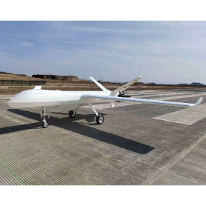
| Wingspan | 2.98 m |
|---|
| Maximum takeoff weight | 24.9 kg |
|---|
| Maximum mission payload | 5 kg |
|---|
| Maximum flight endurance | 3.5 hWith P3-240x; measured outdoors at 80 m altitude in no wind, flying at a constant 17 m/s repeatedly back and forth along a 10 km route until 5% battery remained. |
|---|
| Hover time | 26 minMeasured outdoors at 20 m altitude in no wind, in GPS hover mode until 0% battery remained. |
|---|
| Cruise speed | 60~72 km/h |
|---|
| Maximum range | Approximately 250 km |
|---|
| Altitude ceiling | 6000 m |
|---|
| Wind resistance | Force 6 (10.8~13.8 m/s) / Force 7 (13.9~17.2 m/s)Force 6 for takeoff and landing; Force 7 for level flight. |
|---|
| Takeoff and landing method | Vertical takeoff and landing (VTOL) |
|---|
| Packed dimensions | 1.40 × 0.63 × 0.64 mPacked for transport. |
|---|
| Transport method | Pickup truckWith a custom aviation case. |
|---|
| Control distance | 50 km / 70 km; extendable to 140 km with relayWith relay for the extension to 140 km. |
|---|
| Payload endurance and distance | 3.5 hours covering 250 km; endurance results may vary with environment, use and firmware version.5 kg payload; endurance measured outdoors at 80 m altitude in no wind, flying at a constant 17 m/s repeatedly back and forth along a 10 km route until 5% battery remained. |
|---|
| Gimbal and loudspeaker configuration | TW25 + triple-sensor gimbal + loudspeaker |
|---|
| Mapping camera configuration | TW25 + 225-megapixel five-lens camera |
|---|
| Gimbal and relay configuration | TW25 + triple-sensor gimbal + relay |
|---|
| Fire monitoring demonstration | Autonomous patrol over 1,900 mu; all 3 preset smoke and fire points identified with precise coordinate reporting; infrared identification of a 40 m discontinuous fire line with segment length measurement; real-time transmission to an intelligent firefighting command device.National forestry and grassland fire prevention field trial. |
|---|
| Flight endurance measurement conditions | 80 m altitude; no wind; constant forward speed of 17 m/s; repeated return flights along a 10 km route; ending at 5% remaining battery. Results may vary with environment, use and firmware version.Outdoor flight endurance measurement. |
|---|
| Hover time measurement conditions | 20 m altitude; no wind; GPS hover mode; ending at 0% remaining battery. Results may vary with environment, use and firmware version.Outdoor hover measurement. |
|---|
| Interchangeable mission payloads | Rapid switching between electro-optical gimbals and mapping cameras. |
|---|
| Supported payload types | Electro-optical gimbals, orthographic cameras, five-lens cameras, multispectral cameras and lidar. |
|---|
| Ground control system configurations | Handheld control, dual-screen ground station and modeling workstation configurations supplied as a system. |
|---|
| Flight safety functions | Automatic return and GNSS anomaly handling.Automatic return on low battery or lost connection; anomaly handling for GNSS. |
|---|
| Ground station software | In-house ground station software with one-touch autonomous route planning. |
|---|
| Operational applications | High-altitude mapping, highway inspection, forest fire prevention and power corridor inspection. |
|---|