ChinaDroneRequest a quote →
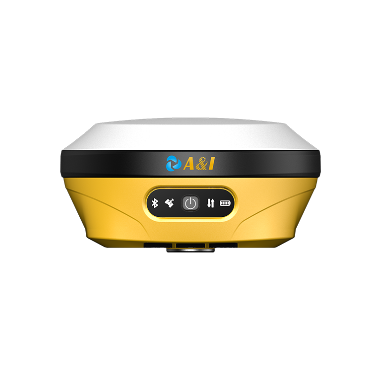
Archimedes Innovation AR15 GNSS receiver with a white top, yellow housing and front control panelArchimedes Innovation AR15 GNSS receiver with a white top, yellow housing and front control panel

Archimedes Innovation AR15

The Archimedes Innovation A&I AR15 is an AR stakeout RTK receiver integrating GNSS, an IMU and a camera for surveying. Augmented reality guides stakeout work, while the IMU self-initializes during regular movement. The receiver combines multi-constellation GNSS, cellular connectivity and an internal radio in a 790g body with IP68 protection.

Archimedes InnovationDrone flight controller

Get a free quote

Product overview

The Archimedes Innovation A&I AR15 is an AR stakeout RTK receiver that combines GNSS, an IMU and a camera for surveying. Augmented reality in the software guides surveyors to stakeout points, while the IMU self-initializes during regular movement. Its UM980 GNSS module provides 1408 channels and a 5Hz update rate, with RTK initialization in <10s. RTK accuracy is ±(8mm+1ppm) horizontally and ±(15mm+1ppm) vertically, expressed as RMS. The integrated AR stakeout camera features a 1/2.8-inch sensor, f/2.5 aperture and 1920*1080 resolution.

The AR15 integrates global 2G/3G/4G, Wi-Fi, Bluetooth, NFC and an internal 410~470MHz receive/transmit radio with switchable 0.5W and 2W transmit power. LoRa communication reaches up to 5 kilometers, depending on the working environment. Its 7.4V, 6500mAh battery provides 16h of operation with CORS through the controller network, and charging supports USB PD 15V/2A and 5V/3A. The receiver measures Φ139mm × 72mm, weighs 790g and has IP68 water and dust protection. It operates from -25℃ to +60℃ and withstands a 2-meter pole drop onto hardwood flooring.
Flight control & navigation

Specifications

Archimedes Innovation AR15 specifications
SpecificationValue & conditions
Product type and constructionArchimedes Innovation A&I AR15 AR stakeout RTK with integrated GNSS, IMU and camera
AR stakeout functionSoftware augmented reality helps surveyors locate stakeout points
IMU initializationHigh-precision IMU self-initializationDuring regular user motion
GPSL1 C/A, L1C, L2P(Y), L2C, L5
GLONASSL1, L2, L3
BDSB1I, B2I, B3I, B1C, B2a, B2b
GALILEOE1, E5a, E5b, E6
QZSSL1, L2, L5
SBASL1
NavICL5
GNSS module and channelsUM980 module; 1408 channels
Update rate5Hz
RTK initialization<10s
RTK accuracyHorizontal: ±(8mm+1ppm); Vertical: ±(15mm+1ppm)RMS
Static accuracyHorizontal: ±(2.5mm+1ppm); Vertical: ±(5mm+1ppm)RMS
AR stakeout accuracyHorizontal: ±(8mm+1ppm); Vertical: ±(15mm+1ppm)AR stakeout
Communication rangeUp to 5 kilometersLoRa mode; depending on the working environment
Wireless connectivityGlobal 2G/3G/4G, WIFI, Bluetooth and NFC
Ports1 × USB Type-C port; 1 × SMA (internal radio); 1 × 7-pin Lemo
Internal radioInternal Rx and Tx, 410~470MHz; switchable 0.5W and 2W transmit power
Radio baud rates and protocols4800bps, 9600bps, 19200bps; TRIMTALK, TRIMMK3, TRANSEOT, SATEL, SOUTH, LoRa
Computing platformARM Cortex-A7; Linux; 8G storage; voice support
Battery and operating duration7.4V, 6500mAh; 16h16h with CORS through controller network
ChargingUSB PD 15V/2A and 5V/3A
Camera specifications
  • Sensor size: 1/2.8 Inch;
  • aperture: f/2.5;
  • resolution: 1920*1080;
  • FOV: 69.3°±3°;
  • distortion: <0.38%
AR stakeout camera
Dimensions and weightΦ139mm × 72mm; 790g
Operating temperature-25℃ ~ +60℃Operating
Storage temperature-40℃ ~ +85℃Storage
Water and dust protectionIP68
Shock resistanceSurvives a 2-meter pole dropHardwood flooring

Related guides