Product overview
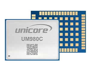
Unicore’s UM980C provides an embedded positioning component for UAV and precision-agriculture integration. Its architecture centers on the NebulasIV GNSS system-on-chip, combining RF, baseband processing and a high-precision algorithm. The receiver accommodates multiple constellations and frequencies through 1408 channels, with RTK and several PPP-related positioning options. Buyers should therefore define the required module configuration around their integration needs.
Physical integration is governed by the published 54-pin LGA package, dimensions of 17.0 × 22.0 × 2.6 mm and weight of 1.88±0.03g; these are manufacturer values to confirm for the selected configuration. Host connections comprise three LVTTL UARTs, plus firmware-dependent SPI, I2C and CAN interfaces. CAN shares with UART3, making interface allocation a procurement consideration. RTCM V3.X differential data and NMEA 0183 or Unicore output formats provide the stated data interfaces, while RTK output is published at up to 50 Hz.
Performance figures distinguish positioning modes and measurement conditions: RTK accuracy is expressed in RMS terms, while PPP, PPP-AR and CLAS figures include specified elapsed times. Initialization below five seconds is explicitly typical. An open-sky, no-jamming qualification whose association with individual rows is unclear. TruePoint|REACH Sat is identified as a paid service, and asterisked interfaces require specific firmware. Environmental procurement checks should preserve the non-condensing humidity condition and treat the vibration and shock entries as published standards references.
Specifications
| Specification | Value & conditions |
|---|---|
| Manufacturer, model and purpose | Unicore UM980C all-constellation, multi-frequency high-precision RTK positioning module.Product classification; the product is a positioning module for integration. |
| Channels | 1408 channels, based on NebulasIV. |
| Frequencies | GPS: L1C/A, L1C, L2C, L2P(Y), L5; BDS: B1I, B3I, B1C, B2a, B2b; GLONASS: G1, G2; Galileo: E1, E5a, E5b, E6; QZSS: L1C/A, L1C, L2C, L5, L6; NavIC: L5; SBAS: L1C/A; L-Band. |
| Single-point positioning | Horizontal: 1.5m; vertical: 2.5m.RMS values. An open-sky, no-jamming qualification without clearly linking it to individual rows; confirm its applicability. |
| DGPS positioning | Horizontal: 0.4m; vertical: 0.8m.RMS values. Confirm applicability of open-sky, no-jamming qualification. |
| RTK positioning | Horizontal: 0.8cm+1ppm; vertical: 1.5cm+1ppm.RMS values. Confirm applicability of open-sky, no-jamming qualification. |
| PPP positioning | Horizontal: 5cm @20min; vertical: 10cm @20min.RMS values at 20 minutes. Confirm applicability of open-sky, no-jamming qualification. |
| PPP-AR positioning | Horizontal: 3cm @5min; vertical: 6cm @5min.RMS values at 5 minutes. The listed TruePoint|REACH Sat service is paid; confirm service configuration and applicability of the open-sky, no-jamming qualification. |
| CLAS positioning | Horizontal: 5cm @1min; vertical: 10cm @1min.RMS values at 1 minute. Confirm applicability of open-sky, no-jamming qualification. |
| Observation accuracy | For each published signal group—B1I/B1C/L1C/L1C/A/G1/E1; B2I/B2a/B2b/L5/E5a/E5b; and B3I/L2P(Y)/L2C/G2/E6/L6—code accuracy is 10cm and carrier-phase accuracy is 1mm in each constellation column.RMS observation values; the published table repeats each value across its BDS, GPS, GLONASS and Galileo columns. |
| Time accuracy | 20 ns.RMS value. |
| Velocity accuracy | 0.03 m/s.RMS value. |
| Time to first fix | Cold start: less than 12 s; hot start: less than 4 s.Separate cold-start and hot-start values; confirm applicability of open-sky, no-jamming qualification. |
| Initialization time | Less than 5 s (typical).Typical value; confirm applicability of open-sky, no-jamming qualification. |
| Initialization reliability | Greater than 99.9%. |
| Data update rate | Up to 50 Hz RTK data output.Maximum published rate specifically for RTK data output. |
| Differential data | RTCM V3.X. |
| Data formats | NMEA 0183, Unicore. |
| Packaging | 54 pin LGA.Module packaging. |
| Dimensions | 17.0 × 22.0 × 2.6 mm. |
| Weight | 1.88±0.03g.With the stated mass tolerance. |
| Working temperature | -40°C to +85°C. |
| Storage temperature | -55°C to +95°C. |
| Humidity | 95%, no condensation.Non-condensing humidity condition. |
| Vibration | GB/T 28046.3, ISO 16750-3.Published standards references. |
| Shock | GB/T 28046.3, ISO 16750-3.Published standards references. |
| Communication interfaces | 3 × UART (LVTTL); 1 × SPI*; 1 × I2C*; 1 × CAN* (shared with UART3).SPI, I2C and CAN require specific firmware. CAN shares with UART3. |
| Firmware, service and measurement qualifications | Asterisked items require specific firmware; note 1 identifies a paid service; note 2 specifies open sky and absence of jamming.Preserve these page-level qualifications. |
| Architecture and application space | NebulasIV GNSS SoC integrates RF, baseband and a high-precision algorithm. Listed applications include UAV and precision agriculture.Architecture and intended applications. |
| Positioning and interference capabilities | Jamming and spoofing detection; STANDALONE single-station positioning; B2b-PPP, E6-HAS and QZSS L6E (MADOCA) PPP; QZSS L6D (CLAS) PPP-RTK; TruePoint|REACH Sat L-band-based PPP-AR.Capabilities. TruePoint|REACH Sat carries paid-service note 1. |
Request a quote for Unicore UM980C
Send your application, destination country and expected quantity to the ChinaDrone team. We can discuss product selection, configuration and sourcing from China.
Submit your procurement requirements ↗No account needed. A model number is optional. Your enquiry is handled by ChinaDrone.