ChinaDroneRequest a quote →
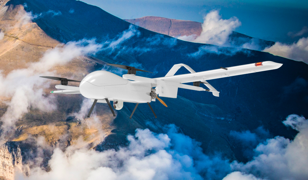
SATPRO FS60G white fixed-wing VTOL drone above mountains and cloudsSATPRO FS60G white fixed-wing VTOL drone above mountains and clouds

SATPRO FS60G

The SATPRO FS60G is a fuel-electric hybrid broadband satellite communications UAV with vertical takeoff and landing, a high-wing layout and an eight-propeller rotor system. Supporting emergency response, forest firefighting, infrastructure inspection and border reconnaissance, it carries up to 23kg and offers 10h endurance with a 10kg payload.

SATPROInspection drone
Maximum endurance
13h
Wind resistance
Force 6
Wingspan
5.2m

Get a free quote

Product overview

The SATPRO FS60G combines a high-wing layout and twin vertical tails with fuel-electric hybrid propulsion and vertical takeoff and landing. Its four-axis, eight-propeller rotor system uses coaxial redundancy to allow safe landing after a single rotor failure. Fixed-wing propulsion comes from a fuel-injected piston engine with integrated starting and generation. The aircraft measures 5.2m in wingspan and 2.72m in length, with a maximum takeoff weight of 70kg and maximum payload weight of 23kg. Maximum endurance is 13h; endurance with a 10kg payload is 10h.

The FS60G supports rapid deployment and packing, cruises at 83-90km/h and has Force 6 wind resistance. It can integrate SATPRO lightweight, high-throughput airborne broadband satellite communications equipment, while radio options cover 30km, 50km and 100km. With an electro-optical gimbal, it can transmit real-time disaster imagery and support forest firefighting through fire-site identification, video and coordinate transmission, burned-area measurement and fire-line assessment.

Carrying a 4G base station, the FS60G can restore public-network communications at disaster sites experiencing three-disruption conditions. Power infrastructure applications include patrols for external damage along power corridors and real-time operating-condition inspections. For oil and gas pipelines, the aircraft collects and transmits inspection data concerning pipeline tapping for oil theft, natural disasters and third-party damage. It also supports long-endurance, wide-area and long-distance border reconnaissance with real-time transmission of imagery from the operating area.
Surveying & inspectionFire & rescue

Specifications

SATPRO FS60G specifications
SpecificationValue & conditions
Product typeSATPRO FS60G broadband satellite communications UAV
Aerodynamic layoutHigh-wing layout with twin vertical tails
Rotor propulsionFour-axis, eight-propeller design
Fixed-wing propulsionFuel-injected piston engine with integrated starting and generation
Takeoff and landingVertical takeoff and landing (VTOL)
Power systemFuel-electric hybrid
Wingspan5.2m
Aircraft length2.72m
Maximum payload weight23kg
Maximum takeoff weight70kg
Maximum endurance13h
Endurance10hWith a 10kg payload.
Cruise speed83-90km/h
Wind resistanceForce 6
Communication link optionsBroadband satellite communications; optional 30km, 50km and 100km radios
Airborne satellite communications equipmentSATPRO lightweight, high-throughput airborne broadband satellite communications equipmentOptional integration.
Rotor redundancyCoaxial eight-propeller redundancy allows safe landingWith a single rotor failure.
Deployment and packingRapid deployment, recovery and packing
Emergency imagingTransmits real-time disaster-site imagery to a command centerWith an electro-optical gimbal payload.
Emergency communicationsRestores public-network communicationsWith a 4G base station payload, at disaster sites experiencing three-disruption conditions.
Forest firefightingIdentifies potential fire sites, returns live video and geographic coordinates, measures burned areas and assesses fire-line lengthWith an electro-optical gimbal payload.
Power infrastructure inspectionPower corridor patrols for external damage and real-time operating-condition inspection
Oil and gas pipeline inspectionReal-time inspection data collection and transmission for oil theft by pipeline tapping, natural disasters and third-party damage
Border reconnaissanceLong-endurance, wide-area, long-distance operations with real-time imagery transmission