ChinaDroneRequest a quote →
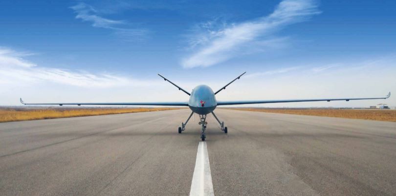
SAT FL-1 surveillance UAV viewed from the front on a runwaySAT FL-1 surveillance UAV viewed from the front on a runway

SAT High Altitude Long Endurance Surveillance UAV

The SAT FL-1 High Altitude Long Endurance Surveillance UAV is a medium-high altitude unmanned aircraft system for reconnaissance, cargo transport, observation and search-and-rescue missions. Its 20m-span platform combines retractable landing gear, GPS/BDS autonomous flight, LOS and satellite control and imaging, and support for radar and photoelectric payloads.

SATInspection drone
Payload
Radar, Photoelectric pod, and others
Cruising speed
≥230 km/h
Wingspan
20m

Get a free quote

Product overview

The SAT FL-1 High Altitude Long Endurance Surveillance UAV is a medium-high altitude, long-endurance unmanned aircraft system for reconnaissance and varied mission loads. Its applications include air logistics and cargo, observation, frontier inspection, and maritime search and rescue. The aircraft has a 20m wingspan, a body length of 10m and a height of 3.8m, with a maximum take-off weight of 3200kg. It uses wheeled take-off and landing with retractable landing gear.

The FL-1 supports GPS/BDS autonomous flight and LOS or satellite control and imaging, with a radius of ≥250km in either mode. Data links use C.UHF within sight and Ku/Ka beyond visual range. Mission payloads include radar and a photoelectric pod. Cruising speed is ≥230km/h, and maximum take-off altitude is ≥3000m. At sea level, takeoff run distance is ≤800m and landing run distance is ≤600m. Automatic return operates following navigation or link equipment failure.
Surveying & inspectionCargo & deliveryFire & rescue

Specifications

SAT High Altitude Long Endurance Surveillance UAV specifications
SpecificationValue & conditions
Manufacturer and productSAT FL-1 High Altitude Long Endurance Surveillance UAV; medium-high altitude long-endurance unmanned aircraft system.
ApplicationsAir logistics and cargo, observation, frontier inspection, and maritime search and rescue.
Wingspan20m
Body length/height10m/3.8m
Max take off weight3200kg
Data linkWithin sight: C.UHF/Beyond visual range: Ku/KaWithin sight / beyond visual range.
Control & Imaging radiusLOS/≥250km,Satellite≥250kmLOS / satellite.
Control & Imaging modeLOS/Satellite
Max take-off altitude≥3000m
Cruising speed≥230km/h
Max climb rate/decline rate≥4m/s
Average climb rate/decline rate≥2m/s
Autonomous flight modeGPS/BDS
PayloadRadar, Photoelectric pod, and others
Take-off and landing typeWheeled take-off and landing, retractable landing gear
Takeoff run distance≤800m(sea level)Sea level.
Landing run distance≤600m(sea level)Sea level.
Safety technical measuresAutomatic return after UAV navigation or link equipment failure.After UAV navigation or link equipment fails.