Product overview
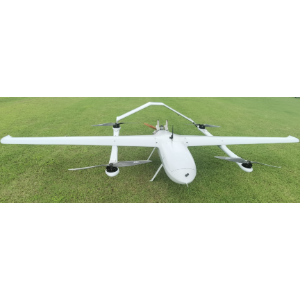
The SAT Chilong 10 (CL-10) combines a fixed-wing layout with vertical take-off and landing for automatic aerial mapping and three-dimensional model generation. Its body measures 1.5m long, with a wingspan of 3.38m. Mission payload and maximum payload are both 3kg, while maximum take-off weight is 15.5kg. With a camera fitted, the aircraft weighs about 13 kg. Installation takes within 10 minutes, and a single operation can cover 20–35 square kilometers. Maximum speed is 120km/h, cruising speed is 70km/h, maximum range is 300km and service ceiling is 4000m.
A thermal camera can be mounted for engineering construction, disaster response, land monitoring, resource development and urban construction missions. Optional data links offer distances of 30km, 50km, 100km and 180km, with high-definition real-time data and video transmission available as options. Ground control support includes handheld, box and vehicle ground stations, together with remote command. Communication station choices include air-to-ground, network and satellite communication stations, providing several ways to support mapping operations and acquire imagery for surveying and land-resource monitoring.