ChinaDroneRequest a quote →
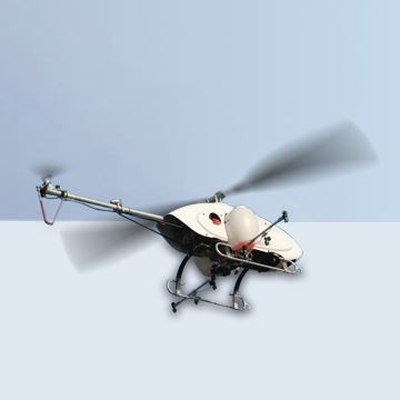
SAT Anti Potential Danger Air Surveillance Uas Drones with Thermal Camera helicopter in flightSAT Anti Potential Danger Air Surveillance Uas Drones with Thermal Camera helicopter in flight

Anti Potential Danger Air Surveillance Uas Drones with Thermal Camera

The SAT Anti Potential Danger Air Surveillance Uas Drones with Thermal Camera is an RC surveillance helicopter with a 170CC engine and redundant autonomous flight control. It supports multiple surveillance sensor payloads, a 20kg mission payload, optional datalinks and electro-optical equipment for reconnaissance, search and rescue, and tracking.

SATInspection drone
Maximum payload
35 kg
Maximum wind resistance
Level 6 (12 m/s)
Overall dimensions
2280 mm*645 mm*720 mm

Get a free quote

Product overview

The SAT Anti Potential Danger Air Surveillance Uas Drones with Thermal Camera is an RC surveillance helicopter for remote-controlled airspace surveillance and autonomous missions. Its redundant autopilot supports operation without human control, while ground remote control and navigation flight control provide additional control methods. Supported sensor payloads include EO/IR, SAR/GMTI radar, LIDAR and hyperspectral equipment. An optional electro-optical pod supports reconnaissance, surveillance, search and rescue, target positioning, identification, tracking and navigation. Beyond-visual-range datalink systems can also be installed.

The helicopter features a 170CC high-powered engine, a 120KG brushless servo and a high-powered on-board generator. Its industrial-grade multi-redundant flight control system supports multi-point track planning and real-time track point uploading. Typical construction comprises a flight platform, navigation flight control and a spraying mechanism. Overall dimensions are 2280mm × 645mm × 720mm, with a 2680mm main propeller and a 470mm tail propeller. Two cabins, measuring 250 × 530 × 150mm and 350 × 530 × 350mm, can be used simultaneously.

Mission payload is 20kg, maximum payload is 35kg including fuel, and maximum take-off weight is 75kg. The helicopter has an 18L fuel tank, a maximum speed of 35m/s, a maximum height of 3000m and maximum wind resistance of level 6 (12m/s). At sea level and an environment temperature of 20°, endurance is 330 minutes empty or 240 minutes with a 20kg load. Optional datalinks cover 30km, 50km, 100km and 180km, with high-definition real-time data and video transmission available.
Surveying & inspectionFire & rescue

Specifications

Anti Potential Danger Air Surveillance Uas Drones with Thermal Camera specifications
SpecificationValue & conditions
Product typeRC surveillance helicopter
Main propeller diameter2680mm
Tail propeller diameter470mm
Maximum payload35kgIncluding fuel.
Maximum take-off weight75kg
Payload designPhotoelectric pod or special design available
Maximum height3000m
Cabin dimensionsA: 250*530*150mm; B: 350*530*350mmBoth cabins can be used at the same time.
Fuel tank18L
Electro-optical pod functionsReconnaissance, surveillance, search and rescue, target positioning, identification, tracking, and navigationOptional electro-optical pod.
Ground control station supportHandheld ground station, box ground station, vehicle ground station, and remote commandOptional system.
Ground communication station optionsAir-to-ground communication station, network communication station, and satellite communication stationOptional system.
Empty-load endurance330 minutesEmpty load; sea level altitude; environment temperature 20°.
Loaded endurance240 minutes20kg load; sea level altitude; environment temperature 20°.
Overall dimensions2280mm*645mm*720mmLength × width × height.
Mission payload20kg
Maximum speed35m/s
Datalink options30km, 50km, 100km, 180km; high-definition real-time data and video transmission optionalOptional datalink configurations.
Maximum wind resistanceLevel 6 (12m/s)
Engine170CC high-powered engine
Servo120KG brushless servo
On-board generatorHigh-powered on-board generator
Flight control systemIndustrial-grade multi-redundant flight control system with multi-point track planning and real-time track point uploading
Autonomous operationRedundant autopilot supports fully autonomous operation without human control
Sensor payload capabilityEO/IR, SAR/GMTI radar, LIDAR, and hyperspectral payloadsSupported sensor payloads.
Beyond-visual-range datalinkBLOS datalink systems for remote-controlled airspace surveillanceOptional installation.
Control methodsGround remote control or navigation flight control
Typical constructionFlight platform, navigation flight control, and spraying mechanism