ChinaDroneRequest a quote →
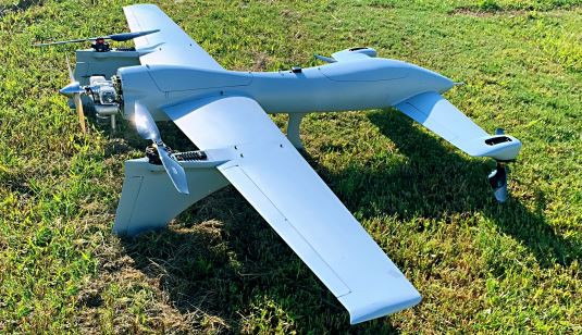
V8 fixed-wing VTOL surveillance drone on grassV8 fixed-wing VTOL surveillance drone on grass

2020 Foldable Multifunctional Long Range Surveying Uav with Radar

The SAT 2020 Foldable Multifunctional Long Range Surveying UAV with Radar, identified as V8, is a small compound VTOL surveillance drone for surveying, monitoring and reconnaissance. Its fixed-wing design combines runway-free take-off and landing with an 8kg maximum payload, modular equipment mounting and a maximum range of 900km.

SATInspection drone
Max endurance
8-9hours
Max payload
8 kg
Wingspan
3.36m

Get a free quote

Product overview

The SAT V8 uses a fixed-wing layout with an optimized aerodynamic design and a fully automatic take-off and vertical landing system. It takes off and lands directly on site without a runway. The aircraft measures 1.85m in body length and 3.36m in wingspan, with a maximum take-off weight of 26kg. Its payload arrangement accommodates reconnaissance equipment, a photoelectric pod or other multi-module mounting, with both mission payload and maximum payload rated at 8kg.

Designed for aerial photogrammetry and surveillance, the V8 also serves disaster monitoring and assessment, emergency monitoring, forest fire prevention, urban firefighting and land resources surveying. It cruises at 70km/h and reaches a maximum speed of 100km/h, with a maximum range of 900km and maximum flight altitude of 4500m. Imaging equipment that can be fitted includes a high-precision, stable photoelectric platform, a hyperspectral imager and full-frame digital cameras. The optional electro-optical pod supports reconnaissance, search and rescue, positioning, identification, tracking and navigation.

Optional systems include data links of 30km, 50km, 100km and 180km, with high-definition real-time data and video transmission available. Ground control options cover handheld, box and vehicle stations as well as remote command; communication options include air-to-ground, network and satellite stations. Emergency protection includes automatic return home, automatic parachute opening and autonomous landing. Up to 100 forced landing points can be preset, while additional protections address navigation faults, low GPS positioning accuracy, control-radius and route-fence exceedance, and prolonged communication interruption.
Surveying & inspectionFire & rescue

Specifications

2020 Foldable Multifunctional Long Range Surveying Uav with Radar specifications
SpecificationValue & conditions
Product typeV8 small compound VTOL surveillance drone
Body length1.85m
Wingspan3.36m
Mission payload8kg
Max payload8kg
Max take-off weight26kg
Payload designReconnaissance, photoelectric pod, or other multi-module mounting
Max speed100km/h
Cruising speed70km/h
Max range900km
Max flight altitude4500m
Max endurance8-9hours
AccuracyAbout 1cm
Data link30km, 50km, 100km, 180km; optional high-definition real-time data and video transmissionOptional system.
Electro-optical podFor reconnaissance, surveillance, search and rescue, target positioning, identification, tracking, and navigationOptional system.
Ground control stationSupports handheld ground station, box ground station, vehicle ground station and remote commandOptional system.
Ground communication stationAir-to-ground communication station, network communication station, satellite communication stationOptional system.
Take-off and landing systemOptimized aerodynamic layout with a fully automatic take-off and vertical landing system
Runway requirementNo runway required; direct take-off and landing on site
Compatible imaging equipmentCan be fitted with a high-precision, stable photoelectric platform, a hyperspectral imager and full-frame digital cameras
ApplicationsAerial photogrammetry, disaster monitoring and assessment, emergency monitoring, forest fire prevention, urban firefighting and national land resources surveying
Preset forced landing points100 forced landing points can be preset, with automatic landing nearby during emergency protectionIn emergency protection.
Emergency protection measuresAutomatic return home, automatic parachute opening and autonomous landing
Navigation and flight protectionProtection for abnormal attitude, low GPS positioning accuracy, integrated navigation system faults, exceeding the maximum control radius or route safety fence, and prolonged communication interruption