Product overview
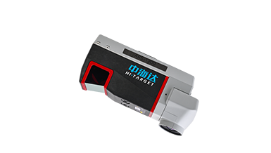
The Hi-Target ARS-1200 combines a laser measurement module, high-resolution imaging unit and UAV platform for airborne surveying. Its multi-angle scanning geometry provides 10° forward and backward views and a 100° lateral field of view for complex terrain, including valleys and building facades. The main unit weighs as little as 2.8kg, with a compact format suitable for a car trunk. Integrated UAV and laser-payload control, a standard interface and independent orthophoto-module support provide flexibility for mapping and inspection operations.
The D10 flight platform has six rotors, a 1300mm wheelbase and onboard RTK/PPK support. Its ratings include 60min endurance, a 10km control radius and a maximum flight altitude of 5500m above sea level. The laser scanner operates at 50–400 lines per second with a maximum pulse frequency of 1800KHz. Maximum measurement range is 1430m at 80% reflectivity, and ranging accuracy is 5mm at 150m. With PP post-processing, positioning accuracy is 0.01m horizontally and 0.02m vertically.
Specifications
| Specification | Value & conditions |
|---|---|
| System architecture | Airborne laser measurement system combining a laser measurement module, a high-resolution imaging unit and a UAV platform. |
| Applications | Topographic mapping, route surveying, power infrastructure inspection, geological hazard investigation and forestry surveys. |
| Main unit weight | As low as 2.8kg. |
| System accuracy | Better than 5cm. |
| Multidirectional viewing geometry | 10° forward and 10° backward, with a 100° lateral field of view and multi-angle scanning. |
| Integrated operation | Integrated control of the UAV and laser payload. |
| Integration interface | Standard interface. |
| Orthophoto module support | Supports an orthophoto module independently. |
| Transport format | Compact enough for a car trunk; transportable on high-speed rail or as checked airline baggage. |
| Laser safety class | Class I. |
| Maximum measurement range | 1430m.80% target reflectivity. |
| Maximum pulse frequency | 1800KHz. |
| Scanning speed | 50–400 lines/second. |
| Range measurement accuracy | 5mm.At 150m. |
| Scan angle | ±50° (100°). |
| Angular resolution | 0.001°. |
| Horizontal positioning accuracy | 0.01m.PP post-processing. |
| Vertical positioning accuracy | 0.02m.PP post-processing. |
| Heading accuracy | 0.010°. |
| Attitude accuracy | 0.005°. |
| Rotor architecture | Six-axis, six-rotor configuration.D10 UAV platform. |
| Wheelbase | 1300mm.D10 UAV platform. |
| Maximum level-flight speed | 20m/s.D10 UAV platform. |
| Maximum flight altitude above sea level | 5500m.D10 UAV platform. |
| Flight endurance | 60min.D10 UAV platform. |
| Control radius | 10km.D10 UAV platform. |
| Wind resistance rating | Level 7.D10 UAV platform. |
| Automatic protection functions | Low-voltage return, return following loss of control, and broken-propeller protection.D10 UAV platform. |
| Onboard RTK/PPK | Supported.D10 UAV platform. |
Request a quote for Hi-Target ARS-1200
Send your application, destination country and expected quantity to the ChinaDrone team. We can discuss product selection, configuration and sourcing from China.
Submit your procurement requirements ↗No account needed. A model number is optional. Your enquiry is handled by ChinaDrone.