| Model and product type | Feifei FX50 firefighting UAV. |
|---|
| Maximum payload | 60kg. |
|---|
| Operating temperature | -25°C to +55°C. |
|---|
| Remote control, telemetry and image transmission distance | ≥5km.Radio line-of-sight conditions. |
|---|
| Continuous hover endurance | 35min.Low altitude; unloaded. |
|---|
| Loaded continuous hover endurance | 8.5min.Low altitude; 60kg payload. |
|---|
| Flight speeds | Level flight ≥10m/s; ascent ≥5m/s; descent ≥3m/s.Low-altitude environment. |
|---|
| High-altitude flight speeds | Level flight ≥8m/s; ascent ≥4m/s; descent ≥2m/s.High-altitude, cold environment. |
|---|
| Navigation equipment | External RTK module and internal GPS module, providing RTK and GPS positioning. |
|---|
| Autonomous flight functions | Autonomous takeoff, cruise flight, fixed-position hovering, autonomous landing and one-button return.Routes preset through software. |
|---|
| Wind and rain tolerance | Wind speed tolerance ≥10m/s; rain tolerance ≥10mL/s.Normal flight and normal hovering. |
|---|
| High-pressure cleaning | The aircraft supports cleaning with a high-pressure water gun.Mounted equipment excluded. |
|---|
| Heat and smoke resistance | Withstands the specified radiant heat and smoke while operating normally.Radiant heat and smoke generated by the 55B oil-pan fire model specified in Table 13 of GB4351.1. |
|---|
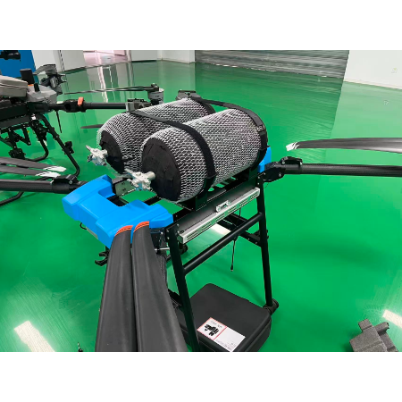
| Payload mounting design | Supports three simultaneous payload mounts with a modular quick-release design. |
|---|
| Payload types and changeover | Fire-extinguishing bombs, water bags and detection modules; changeover within minutes. |
|---|
| Automatic safety functions | Automatic return after control-signal loss; automatic alarm and forced landing when battery power is insufficient.Remote-control signal interruption or insufficient battery power. |
|---|
| Mission capability | Carries fire-extinguishing bombs or rescue supplies for firefighting and delivery to trapped people.High-rise building firefighting and rescue. |
|---|
| Weather safety mode | Automatically seeks a safe area to hover or land.Wind or rain exceeds the 10m/s or 10mL/s threshold. |
|---|
| Training support | Manufacturer-provided firefighting training; simple reconnaissance tasks after 1–2 days, with advanced training required for complex firefighting.Training in basic flight and mission payloads, including simulated fire exercises. |
|---|
| Transmission limitation and relay options | Obstructions reduce the 5km line-of-sight distance; ground or airborne relay modules and UAV mesh relaying can extend image transmission.Mountain obstructions along the radio path. |
|---|
| Route flight with a weak image link | RTK positioning operates independently of image transmission, supporting autonomous route flight.Weak image-transmission signal. |
|---|
| Illustrative bomb capacity and release operations | Six bombs carried; approximately 3–4 release operations.Assumed 10kg per bomb; 60kg payload; 8.5min hover endurance; round-trip flight time deducted; dependent on fire-site distance. |
|---|
| Design life and consumable replacement | Airframe structure and flight-control module design life exceeds 5 years; batteries and other consumables require replacement every 2–3 years.Average 300 firefighting missions per year. |
|---|
| Multi-aircraft coordination | Supports formation operations coordinated through a ground station.Formation with UAVs of the same type. |
|---|
| Command-system connectivity | Image data can connect to firefighting command systems and firefighters’ handheld terminals. |
|---|
| Automatic health checks | Automatically checks propulsion, flight-control and positioning modules and reports risk items.Before takeoff. |
|---|
| Sealing and maintenance | Waterproof sealing design; dry promptly after washing and regularly inspect sealing strips, especially at payload interfaces.After washing and during periodic maintenance, particularly at payload interfaces. |
|---|
| Gust response | Activates attitude stabilization, then seeks sheltered or low-lying areas to hover or automatically plans an upwind return route.Monitored wind speed exceeds the threshold. |
|---|