Product overview
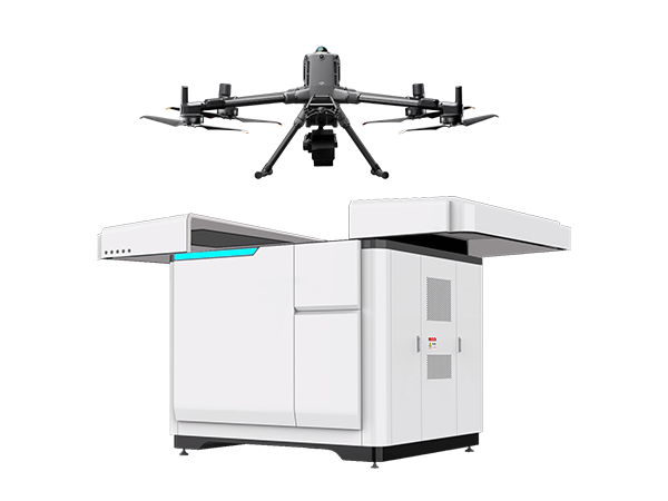
The Caipu Keji (Zhejiang) FS-AP-60C combines an FS60C hyperspectral camera, DJI M400 aircraft, and FS-AP automated dock into an ecological monitoring system. Its physical architecture places a lightweight spectral payload on the flight platform and supports aircraft handling through the ground installation. The dock combines storage, takeoff and landing, recovery, battery exchange, and data processing. This configuration supports an unattended workflow spanning energy replenishment, mission execution, spectral data acquisition, and analysis, with automated mission planning and execution.
Integration extends to analytical models, external reference measurements, and user data infrastructure. Built-in deep-learning functions allow users to import models, train them, and upgrade them for their applications. Water-quality monitoring and vegetation-index analysis are included analytical functions, supporting work across agriculture, forestry, water monitoring, and urban environmental management. Third-party laboratory or online monitoring-station measurements can provide reference data for automatic calibration of airborne analysis results. That calibration function depends on access to the external high-precision measurements used as its reference.
The ground-station interface gives operators remote access to equipment status, mission progress, and live data streams, with manual takeover available when necessary. Autonomous flight functions include route planning and dynamic obstacle avoidance. Live measurements can be processed and inverted for cloud upload; the live transmission route passes through the aircraft link and remote controller before reaching the user's platform. A separate post-flight workflow uses the dock's configured server and network to download and compute data after the aircraft returns, then upload it to the user's server.
Specifications
| Specification | Value & conditions |
|---|---|
| Product type and model | FS-AP-60C intelligent airborne hyperspectral drone docking system. |
| Monitoring purpose | Unattended ecological monitoring with remote operation through a drone docking station. |
| System configuration | Lightweight hyperspectral payload integrated with a DJI M400 aircraft and the manufacturer's FS-AP automated docking station; a flight-platform system. |
| Hyperspectral camera | Manufacturer's FS60C camera for hyperspectral data acquisition. |
| Aircraft | DJI M400 flight platform for hyperspectral data collection. |
| Automated dock | Manufacturer's FS-AP dock combines aircraft storage, takeoff and landing, battery exchange, and data processing. |
| Base-station functions | Eight functions: intelligent aircraft storage, autonomous takeoff and landing, intelligent operations, automatic recovery, automatic battery exchange, data return, intelligent analysis, and battery hot swapping. |
| Unattended workflow | Automated workflow covers energy replenishment, mission execution, data collection, and analysis without on-site intervention. |
| Mission automation | Automated mission planning and execution, autonomous flight, intelligent route planning, and dynamic obstacle avoidance. |
| Remote monitoring and control | Ground-station visual interface provides equipment status, mission progress, and live data streams, with manual control takeover when needed. |
| Algorithm integration | Built-in deep-learning algorithms support importing additional models, user training, and upgrades. |
| Real-time processing | Processes and inverts live hyperspectral measurements, with real-time upload of results to a cloud platform. |
| Built-in analytical applications | Includes water-quality monitoring and vegetation-index analysis algorithms. |
| Agricultural applications | Crop-growth monitoring and guidance for precision fertilization. |
| Forestry applications | Forest-resource inspection and pest and disease early warning. |
| Water and urban applications | Water-pollution monitoring, urban ecological assessment, and urban greenery monitoring. |
| External calibration | Automatically calibrates airborne remote-sensing analysis results using external reference data to correct systematic errors.Using high-precision data from third-party laboratories or online monitoring stations. |
| Post-flight data handling | Automatically downloads and computes flight data, then uploads it to the user's server.After the aircraft returns; using the server and network configured in the automated dock. |
| Live data route | Live data travels to the aircraft remote controller and is forwarded to the user's data platform.Through the aircraft signal link and remote controller. |
Request a quote for FS-AP-60C
Send your application, destination country and expected quantity to the ChinaDrone team. We can discuss product selection, configuration and sourcing from China.
Submit your procurement requirements ↗No account needed. A model number is optional. Your enquiry is handled by ChinaDrone.