Product overview
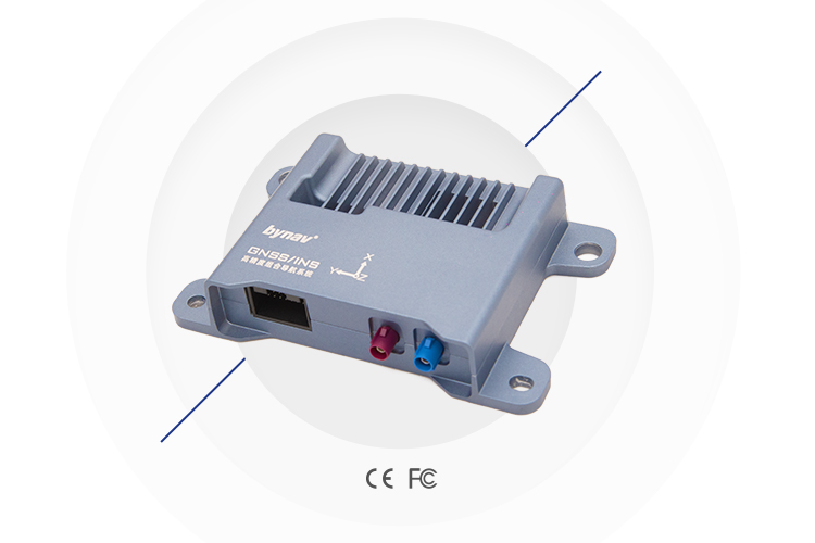
The bynav X36D GNSS/INS Positioning Box provides position, velocity and attitude information for navigation and mapping applications, including UAV integration. Its GNSS receiver uses bynav-developed chips and incorporates a high-precision IMU compliant with functional safety ASIL B standards. The box measures 153 × 100 × 30 mm and weighs 290±30 g, defining its physical integration footprint. Automotive Ethernet and CAN/CAN FD interfaces, together with PPS and gPTP support, provide connections and synchronization for interaction with other sensors such as LIDAR and SLAM.
Maximum output rates are 5 Hz for GNSS measurements and RTK positions, and 100 Hz for INS position/attitude and raw IMU data. GNSS/IMU raw data output and post-processing are supported. Accessory options comprise GNSS antenna kits, a USB-RS232 converter cable, a 4G DTU kit and rover and base-station radio kits. Accuracy varies with positioning mode and GNSS interruption: RTK horizontal position accuracy is 0.015 m RMS at zero outage and 0.235 m RMS after a 10-second outage; corresponding PP values are 0.010 m and 0.015 m RMS.
Specifications
| Specification | Value & conditions |
|---|---|
| Navigation configuration | Full-temperature calibrated IMU, deeply coupled navigation algorithm and dual antennasX36D configuration described by the manufacturer |
| Application optimization | In-vehicle applicationsBased on vehicle characteristics modeling |
| System type | GNSS/INS receiver |
| Satellite systems and signals |
|
| Horizontal positioning accuracy | Single point: 1.5 m (RMS); RTK: 1 cm + 1 ppm (RMS)Single-point or RTK positioning. |
| Vertical positioning accuracy | Single point: 2.5 m (RMS); RTK: 1.5 cm + 1 ppm (RMS)Single-point or RTK positioning. |
| Time to first fix |
|
| Maximum data rates |
|
| Carrier-phase measuring accuracy | ≤1 mm (RMS)Carrier-phase measurement. |
| Pseudorange measuring accuracy | L1C/A, L2, G1, G2: ≤0.12 m (RMS); other signals: ≤0.06 m (RMS)Pseudorange measurement on the specified signals. |
| Timing accuracy | 20 ns (RMS) |
| Velocity accuracy | 0.03 m/s (RMS) |
| Velocity limit | 300 m/s |
| Dimensions | 153 × 100 × 30 mm |
| Weight | 290±30 g |
| Accuracy at 0 s outage, RTK |
|
| Accuracy at 0 s outage, PP |
|
| Accuracy at 10 s outage, RTK |
|
| Accuracy at 10 s outage, PP |
|
| Gyroscope range | ±300 °/sGyroscope. |
| Gyroscope rate bias repeatability | 0.5 °/sGyroscope. |
| Gyroscope rate bias instability | 1.8 °/h (XZ); 1.4 °/h (Y)Gyroscope; X/Z and Y axes. |
| Angular random walk | 0.09 °/√h (XY); 0.10 °/√h (Z)Gyroscope; X/Y and Z axes. |
| Accelerometer range | ±6 gAccelerometer. |
| Accelerometer rate bias repeatability | 20 mgAccelerometer. |
| Accelerometer rate bias instability | 15 μgAccelerometer. |
| Velocity random walk | 0.035 m/s/√hAccelerometer. |
| Interfaces and synchronization | Automotive Ethernet, CAN/CAN FD, PPS and gPTP; interaction with other sensors such as LIDAR and SLAM |
| Raw data and post-processing | GNSS/IMU raw data output and post-processing supported |
| IMU functional safety | High-precision IMU compliant with functional safety ASIL B standards |
| Accessory configurations | BY500-5M-FAKRAC kit: GNSS antenna ×1, TNC-FAKRAC converter cable ×1, mounting base ×1. BY500-5M-FAKRAD kit: GNSS antenna ×1, TNC-FACKRAD converter cable ×1, mounting base ×1. USB-RS232 converter cable ×1. MD-649 4G DTU kit: communication module ×1, 4G antenna ×1, power adapter ×1, public-to-public cable ×1. DU2601D rover radio kit: receiver module ×1, radio antenna (M) ×1, power supply ×1. HX-8616D-SE base radio kit: 5W transmitter ×1, radio antenna (L) ×1, power supply ×1.Accessory and evaluation-kit configurations. |
Request a quote for Bynav X36D GNSS/INS Positioning Box
Send your application, destination country and expected quantity to the ChinaDrone team. We can discuss product selection, configuration and sourcing from China.
Submit your procurement requirements ↗No account needed. A model number is optional. Your enquiry is handled by ChinaDrone.